
快速導覽
Details of the route to be taken
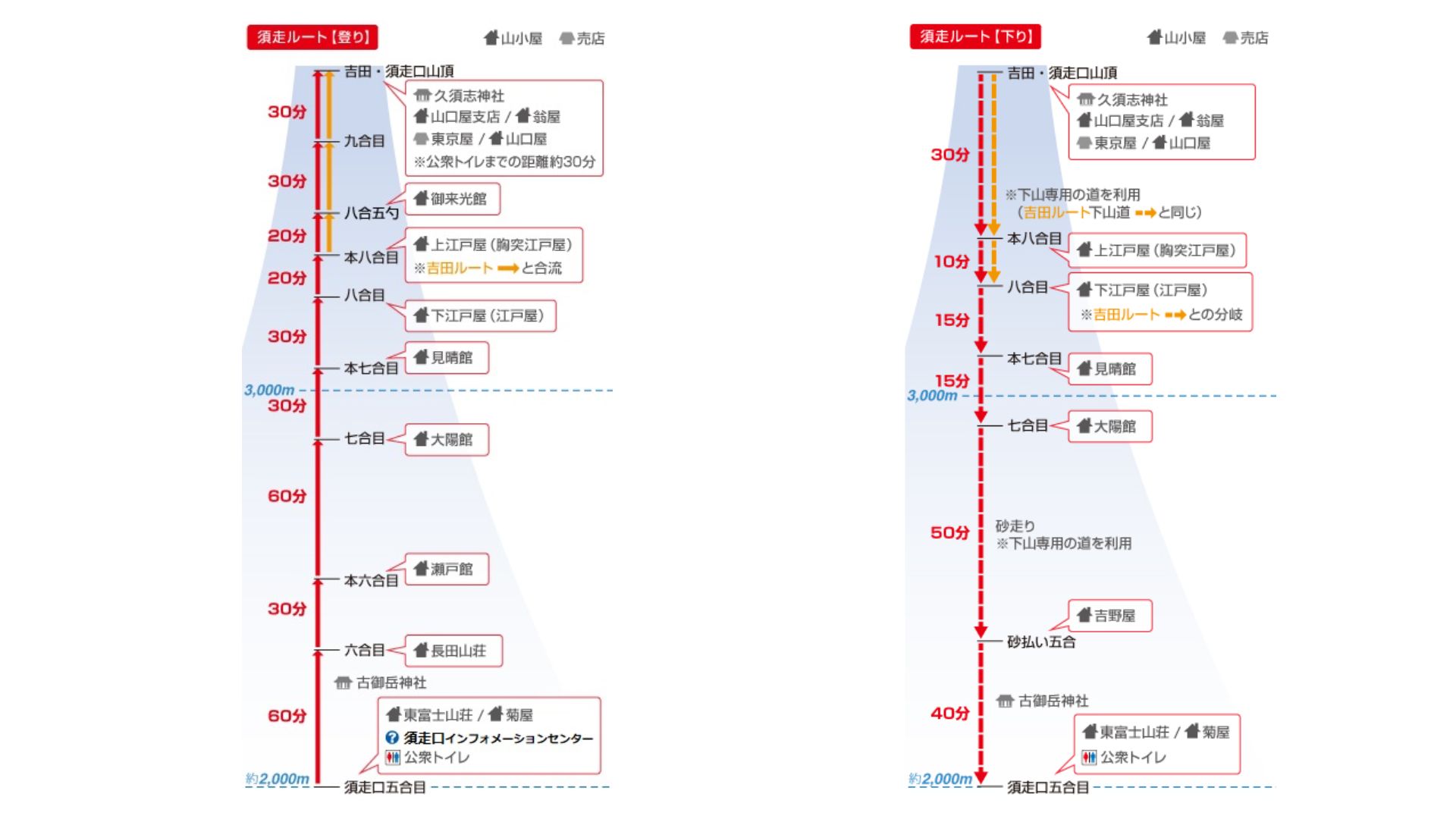
| starting height | about 2000m |
| Elevation difference from the top of the mountain | about 1700m |
| Walking distance uphill | about 7.8km |
| Walking time uphill | About 6 hours and 30 minutes |
| Walking distance downhill | about 6.2km |
| Walking time downhill | about 3 hours |
| Hiking trail location | Side view of Shizuoka Prefecture (within Oyama Town) |
| The direction of the hiking trail | Start from the east side of Mount Fuji and climb to the top of Mount Fuji |
| Starting point of the hiking trail | Subashiri Exit 5th Station |
| Congested conditions on hiking trails | generally |
Main features of the required route:
- There is a forest belt on the hiking trail, and you have the opportunity to see the forests and plants of Mount Fuji.
- The path down the mountain is in a straight line, and you can experience the fun of sliding in the sand with "Grand Sand Walking".
- The hiking trail heading up the mountain joins the Yoshida Line at the eighth station.
- The uphill direction and the downhill direction of the required route are divided into two independent climbing paths. Climbers going down the mountain and climbers going down the mountain will take two different routes.
- At night and during thick fog, the hiking trails in the forest zone will have insufficient light. You must be careful not to get lost and pay attention to the risks.
Mountain hut information that requires walking distance
Compared with the Yoshida Line, the number of mountain huts required to take the line is relatively small. For example, comparing the number of mountain huts with an area of less than 8 and 5 scoops, there are more than 10 mountain huts on the Yoshida Line, but only 8 mountain huts on the Subaki Line.
In other words, if you want to buy food and drinks more conveniently during mountain climbing, the Yoshida Route on Mount Fuji should be more suitable for you.
More Mount Fuji climbing information: Mount Fuji climbing preparation checklist / Mount Fuji equipment list / Mount Fuji mountain hut list
A must-buy transportation package for climbing Mount Fuji: Shinjuku – Mount Fuji JR Ticket / Tokyo Airport Skyliner Ticket / JR Pass Tokyo Wide Area Pass

More information on Mount Fuji climbing routes:
Yoshida Line / whiskers / Gotemba Line / Fujinomiya Line

Seize opportunities to save on travel expenses
[The most complete] Latest deals on Tokyo attractions/tickets
From tickets to travel experiences, we have it all!
Information on hiking trails that must be followed
There are many similarities between the Subashiri Line and the Yoshida Line, whether it is the height of the starting point or the hiking trail that merges halfway to the top of Mount Fuji.
The uphill direction of the route to be taken
There is a small shop and restrooms at the entrance to the trail where you must follow the trail.
Starting from the 5th station of the Subashiri Line, pass in front of Koomitake Shrine, then pass through the forest belt, and then you can slowly climb to the 8th station. In addition, when you walk near the seventh station, the shade of the trees will begin to become sparse, which is the best place to enjoy the sunrise and take pictures of Mount Fuji's reflection in the morning.
Since there are no ambulance stations along the route, if you encounter any emergencies or emergencies, you must call immediately110/119 to the emergency rescue team.
The tourist information center is located near the entrance to the 5th station parking lot on the corridor. The tourist information center will provide climbing routes, weather information, and route guidance services to climbers. Please note that the tourist information office will only operate when the hiking trails are open. When the hiking trail is closed, the tourist information center will be closed at the same time. In addition, the tourist information center will provide reservation information for mountain huts, and staff who can speak foreign languages will provide guidance services to climbers.
There are two small shops at the 5th station of Subashiriguchi, which are usually open until November. However, this small shop only sells drinking water and simple mountaineering equipment. If you need some professional mountaineering equipment, you should prepare it before you start climbing Mount Fuji. In addition, if you run out of drinking water during mountain climbing, you can also buy it from the mountain huts along the way.
Location of paid restrooms: There is a public restroom open 24 hours a day at the 5th station of Subashikou. In addition, there are paid restrooms open 24 hours a day at the 6th Station, Main 6th Station, 7th Station, Main 7th Station, and 8th Station.
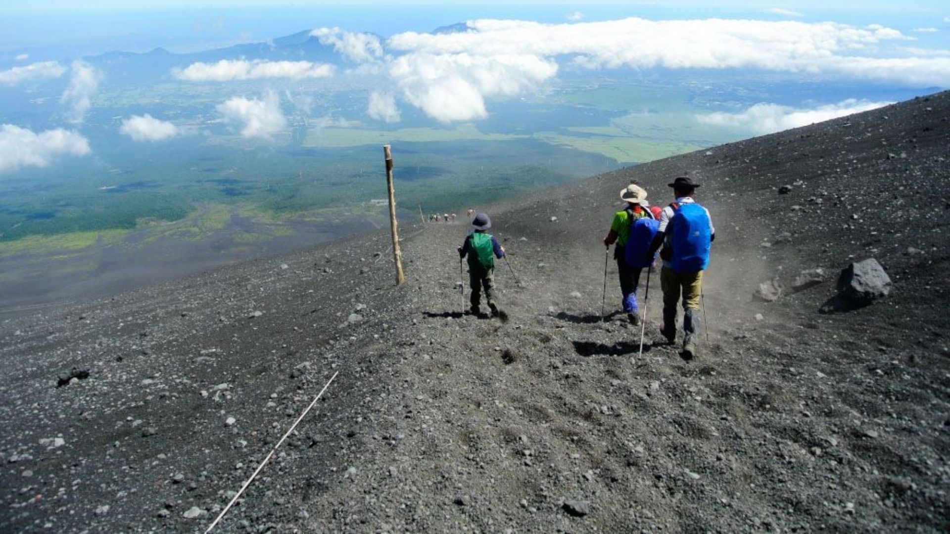
After arriving at the 8th station, since the Subaru route will merge with the Yoshida route, you will encounter the crowds of people rushing to reach the top of Mount Fuji before sunrise. Be careful to keep warm and avoid colliding with climbers next to you.
Like the Yoshida Route, the area above the 8th station that must be followed is owned by the Fujisan Maingu Sengen Taisha Shrine and Okumiya. It is the obligation of every climber to protect the natural environment of Mount Fuji and respect the culture of Mount Fuji.
There are also paid restrooms on the Subashiri Line at the 8th station, located at the 8th station, 5th station, and the mountain hut at the top of the mountain.
The downhill direction of the route to be taken
To descend from Mount Fuji, you need to use the dedicated descent path to return to the starting point of the hiking trail. Before arriving at Shimoedoya, all the descent routes you need to take will use the same climbing route as the Yoshida Line. When you arrive at Shimoedoya, a sign will appear showing the direction of the red route and the yellow Yoshida route.
After reaching the bifurcation point of the Subashiri Line and the Suyoshida Line, if you plan to return to the starting point of the hiking trail from the Subashiri Line, you need to continue down the mountain in the direction indicated by the red.In the morning of the day, there will be Japanese climbing instructors on duty at the different points. If you have any questions, be sure to ask first and then clear them up before continuing your journey down the mountain.
Restroom locations: The mountaintop restroom provided by the Environment Bureau (opening hours are from 4 a.m. to 4 p.m.), the upper Edoya of the eighth station (open 24 hours), the lower Edoya of the eighth station (open 24 hours), This is the 7th Station Miharukan, the 7th Station Taiyokan, and the 7th Station Yoshinoya. Most of the above restrooms are paid restrooms, with an average charge of ¥300 yen each time, and usually only ¥100 yen coins are accepted.
The downhill path that requires walking is a relatively flat straight line, where you can experience the fun of sliding on the sand.
After reaching the fifth station of the downhill path, you will reach the forest zone. At this time you need to prepare a headlamp to cope with this section of the road. After passing through the forest belt, you will arrive at the Subashiriguchi 5th Station.
Summarize
Which climbing route on Mount Fuji is best for first-time climbers? The Yoshida Route has the most mountain huts and the richest tourist facilities, so it is naturally the most suitable climbing route for you to climb Mount Fuji.
However, if you want to experience the fun of sliding in the sand, you can also consider climbing to the top of Mount Fuji from the Subashiri Line. But before you start mountaineering, you must prepare a complete set of mountaineering equipment, as well as sufficient food and drinking water, and then you can start your mountaineering trip.
More tourist information on the Mt. Fuji area
Preparation before climbing Mount Fuji
Fuji Mountain Climbing 2024》First summit strategy/climbing route/climbing time & necessary information
Mt Fuji Packing List: What to Wear & What to Bring When Climbing Mt. Fuji
Mt. Fuji Hut Reservation: Complete Guide to Book Goraikoukan (Highest Mountain lodge of Mt. Fuji)
Fuji Mountain Climbing Route List》Opening Hours/Route Map Overview
Fuji Mountain Hut Reservation Information Checklist & 7 Essential Things During Your Stay
⋯⋯and MORE
Recommended itinerary after climbing Mount Fuji
Mount Fuji, Lake Kawaguchi, and Hakone travel information
Tokyo Travel Information
Mount Fuji, the latest travel deals in Tokyo
Kawaguchiko Onsen Hotel Deals
Hakone Onsen Hotel Deals
Tokyo Hotel Deals
Tokyo attractions ticket discounts
More Japan Travel Information:
Tokyo|Kyoto|Hokkaido|Climbing Mt.Fuji|Hakone|Lake Kawaguchi
Tips for Traveling in Japan | Japan Hotel Deals | Klook Latest Promo Code